
OuterMap

Parks in Finlayson

Finlayson, Minnesota, United States has 1 park to explore on OuterMap: Banning State Park. It has 13 mapped trails and 14 points of interest.

Places

  1. #1 · Banning State Park

    0.0(0)ParkFinlayson13 trails

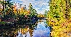
    Banning State Park is filled with gorgeous scenery, historic significance and recreational adventure. The park was created in 1963 to protect a unique landscape along the Kettle River. The river itself is a favorite of whitewater paddlers. With five sets of rapids ranging from Class III-V, it offers a wavy playground for experienced paddlers. Hikers can enjoy river views from 17 miles of scenic trails. Watch for wildlife, climb through unique geological formations, and visit two waterfalls during your stay. Stop along the Quarry Loop Trail to explore the ruins of a 130-year-old sandstone quarry. See the quarry wall that still bears the marks of steam-powered drills and find the skeletons of the rock crusher and power house buildings.

Frequently Asked Questions

How many parks are there in Finlayson?

OuterMap has 1 park in Finlayson, Minnesota, United States: Banning State Park.

What is the longest trail in Finlayson?

The longest mapped trail in Finlayson is Hiking (Wolf Creek Trail + Wolf Creek Falls Trail) + Wolf Creek Falls Trail at Banning State Park, at 2.1 miles.

Where can I camp in Finlayson?

Banning State Park has campsites marked on its map.

Where can I have a picnic in Finlayson?

Banning State Park has picnic areas marked on its map.

Download The App & Explore Anywhere

Explore interactive maps, discover trails and points of interest, and navigate confidently with the OuterMap mobile app — with detailed information and offline access wherever you go.