
OuterMap

Parks in Brainerd

Brainerd, Minnesota, United States has 1 park to explore on OuterMap: Crow Wing State Park. It has 6 mapped trails and 23 points of interest.

Places

  1. #1 · Crow Wing State Park

    0.0(0)ParkBrainerd6 trails

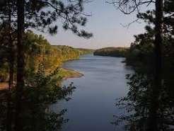
    Crow Wing State Park lies at the confluence of the Crow Wing and Mississippi rivers, which have been important canoe and trade routes for many people over time. In the mid-1800s, a bustling community existed here. Discover evidence of the park’s past by visiting the Old Crow Wing Town Site and Red River Oxcart Trail, both Historic Districts on the National Register of Historic Places. The park was in 1959 to preserve these significant pieces of Minnesota’s history. The 3,119-acre park also has a rich natural history with three of Minnesota’s major landscapes (pine, prairie and hardwood) containing diverse plants and wildlife.

Frequently Asked Questions

How many parks are there in Brainerd?

OuterMap has 1 park in Brainerd, Minnesota, United States: Crow Wing State Park.

What is the longest trail in Brainerd?

The longest mapped trail in Brainerd is Paved (Paul Bunyan State trail/Missisippi River Trail) at Crow Wing State Park, at 6.4 miles.

Where can I camp in Brainerd?

Crow Wing State Park has campsites marked on its map.

Where can I have a picnic in Brainerd?

Crow Wing State Park has picnic areas marked on its map.

Download The App & Explore Anywhere

Explore interactive maps, discover trails and points of interest, and navigate confidently with the OuterMap mobile app — with detailed information and offline access wherever you go.