
OuterMap

Parks in Argyle

Argyle, Minnesota, United States has 1 park to explore on OuterMap: Old Mill State Park. It has 5 mapped trails and 24 points of interest.

Places

  1. #1 · Old Mill State Park

    0.0(0)ParkArgyle5 trails

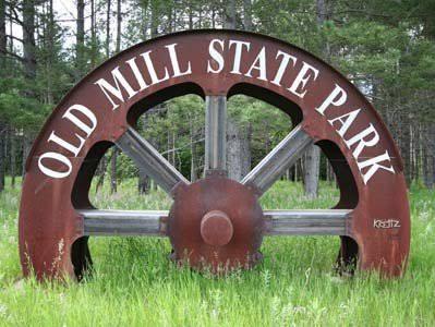
    Old Mill State Park is a small Minnesota state park on the Middle River between Argyle and Newfolden on an ancient beach of glacial Lake Agassiz in Marshall County in the northwestern part of the state. It is a 406-acre (164 ha) park.

Frequently Asked Questions

How many parks are there in Argyle?

OuterMap has 1 park in Argyle, Minnesota, United States: Old Mill State Park.

What is the longest trail in Argyle?

The longest mapped trail in Argyle is Hiking (Riverine Forest/Grouse Drum/Larson Pines/Aspen-Oak/Painted Turtle/Native Prairie/River View Trail) at Old Mill State Park, at 4.6 miles.

Where can I camp in Argyle?

Old Mill State Park has campsites marked on its map.

Where can I have a picnic in Argyle?

Old Mill State Park has picnic areas marked on its map.

Download The App & Explore Anywhere

Explore interactive maps, discover trails and points of interest, and navigate confidently with the OuterMap mobile app — with detailed information and offline access wherever you go.