Hospital Wayfinding Solutions: A Complete Guide to Better Hospital Navigation
Hospitals can be difficult to navigate, especially when patients and visitors need to find a specific department, clinic, exam room, laboratory, pharmacy, parking area, or emergency department within a large or multi-building facility. Complex layouts, multiple floors, unfamiliar terminology, and changing routes can make even a short journey confusing.
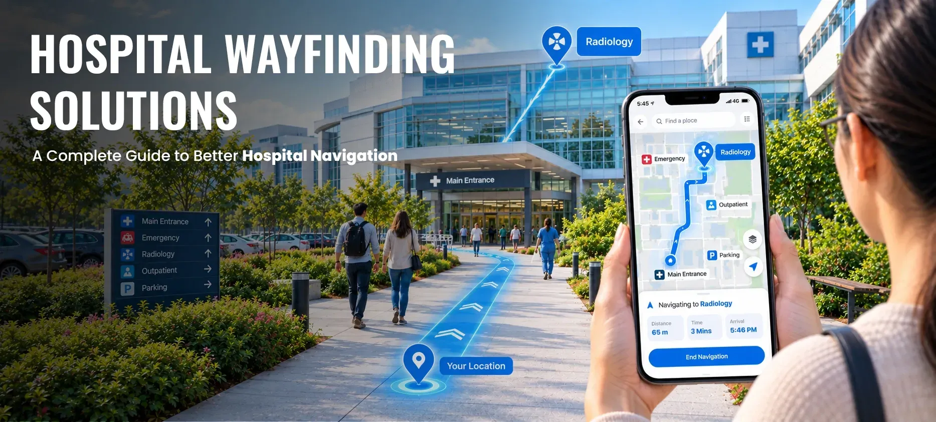
Hospital wayfinding solutions help healthcare organizations make these journeys easier by combining maps, directional information, route guidance, accessibility options, and other navigation tools.
Traditional signs remain an important part of hospital navigation, but digital wayfinding can add another layer of guidance by helping users search for destinations, understand routes, and navigate between outdoor and indoor spaces.
This guide explains what hospital wayfinding is, how hospital wayfinding systems work, what to look for in hospital wayfinding software, and how healthcare organizations can approach digital navigation.
What Is Hospital Wayfinding?
Hospital wayfinding is the process of helping patients, visitors, staff, and other users understand where they are, where they need to go, and how to reach their destination within a healthcare facility or campus.
A hospital wayfinding system can include:
- Directional and identification signs
- Building and floor maps
- Color and visual coding
- Directories and destination information
- Interactive digital maps
- Indoor navigation
- Accessible route guidance
- Outdoor campus navigation
- Emergency and safety information
Effective wayfinding is not simply about placing more signs around a hospital. It is a coordinated system that helps people make navigation decisions from the moment they arrive until they reach their destination.
Queensland Health's Wayfinding design principles describe healthcare wayfinding as a coordinated system that can combine environmental cues, signage, and digital tools.
Why Is Hospital Wayfinding Important?
Hospital environments are often more complex than ordinary public buildings. A healthcare campus may include multiple buildings, departments, entrances, parking areas, elevators, corridors, clinics, diagnostic facilities, and restricted areas.
For patients and visitors, navigation difficulties can create confusion and unnecessary stress. Staff may also need to spend time repeatedly providing directions when users cannot easily find their destinations.
Research published in Applied Ergonomics has examined digital wayfinding in hospitals and reported potential benefits including reduced task complexity and user stress, greater user control, and less staff time spent providing directions. The research also highlights the importance of addressing the needs of elderly users and people with disabilities.
Better wayfinding can therefore support several important goals:
- Help patients find the correct destination
- Make visitor journeys easier to understand
- Support accessible navigation
- Reduce confusion in complex facilities
- Help staff spend less time giving routine directions
- Improve the overall navigation experience
- Provide more consistent information across buildings and floors
Wayfinding should complement the broader patient and visitor experience rather than be treated as a standalone technology project.
What Are Hospital Wayfinding Systems?
Hospital wayfinding systems are the combined physical, digital, and environmental tools used to help people navigate healthcare facilities.
A complete system may include physical signage, directories, maps, architectural landmarks, digital maps, and route guidance.
For example, a visitor arriving at a medical campus may need to:
- Find the correct parking area.
- Identify the appropriate building entrance.
- Locate a department inside the building.
- Find the correct floor.
- Choose an elevator or accessible route.
- Follow the route to the destination.
A well-designed wayfinding system should provide consistent information throughout this journey.
This is why digital tools should not automatically replace physical signage. Instead, digital navigation can complement signage and other environmental wayfinding elements.
How Do Hospital Wayfinding Systems Work?
A hospital wayfinding system generally begins with accurate information about the healthcare environment.
This can include:
- Building locations
- Floor plans
- Entrances and exits
- Departments and clinics
- Patient services
- Elevators and stairs
- Corridors and connections
- Parking areas
- Accessible entrances
- Other points of interest
That information can then be organized into a map and routing system.
When a user searches for a destination, the system can identify the destination and provide a route from the user's selected starting point.
For a large healthcare campus, the route may need to connect outdoor and indoor areas. For example:
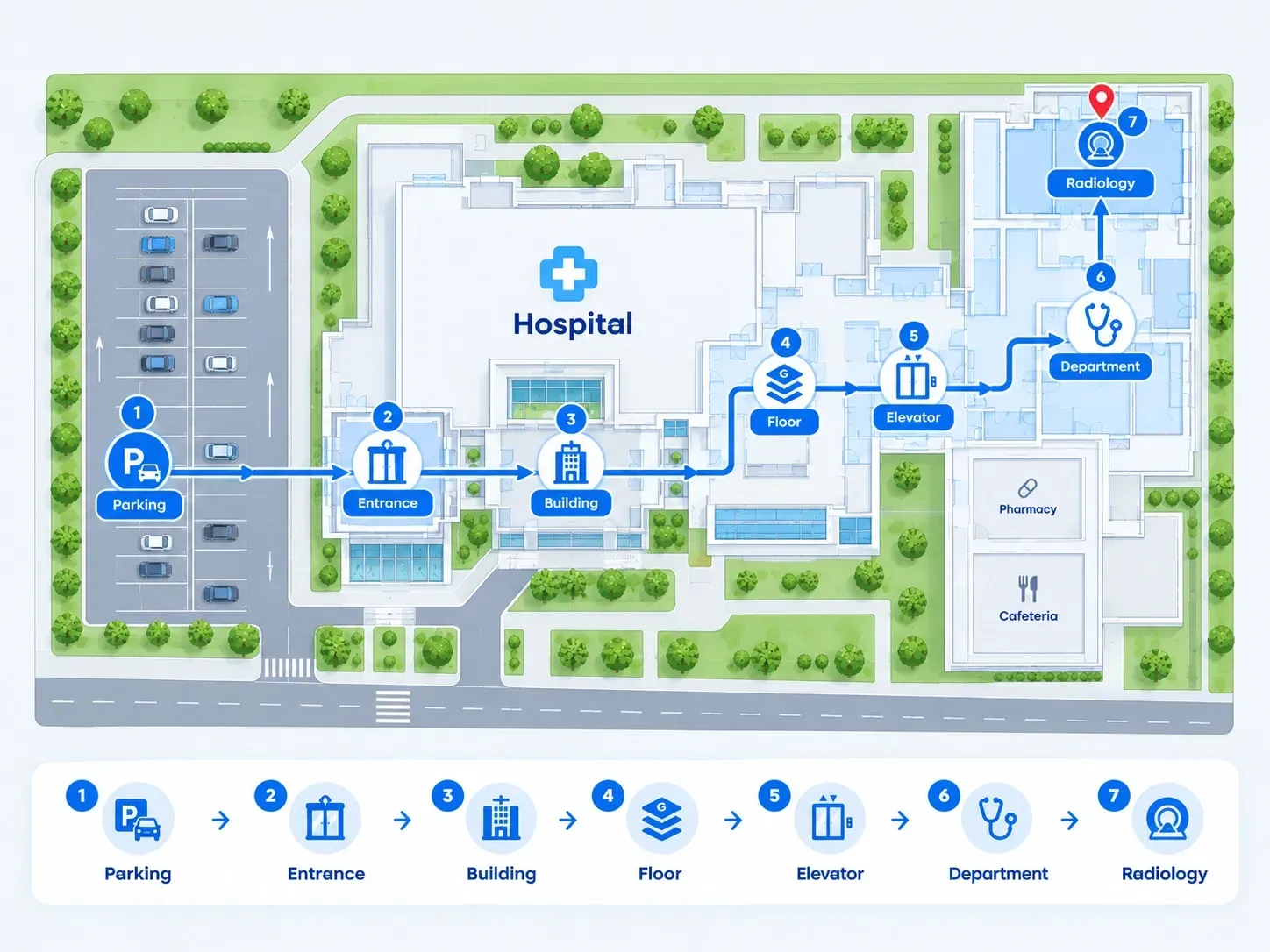
Parking → Hospital entrance → Building → Floor → Elevator → Department → Destination
This type of connected journey is especially useful when a hospital has multiple buildings or floors.
What Are Digital Hospital Wayfinding Solutions?
Digital hospital wayfinding solutions use software, digital maps, and route guidance to help people navigate healthcare environments.
Depending on the technology and implementation, users may access navigation through a web browser, mobile device, kiosk, or dedicated application.
A digital system can allow users to:
- Search for destinations
- View interactive maps
- Select a starting point
- Follow route guidance
- Navigate between floors
- Navigate between buildings
- Find parking and entrances
- Select accessible route options
- Share a location or route
- Access information in multiple languages, when supported
Digital navigation can be particularly useful when hospital layouts are large, complex, or frequently updated.
For a broader explanation of the technology, see how digital wayfinding works.
What Is Hospital Indoor Navigation?
Hospital indoor navigation focuses on helping users navigate inside buildings where conventional outdoor GPS may not provide sufficient location detail.
Indoor navigation can connect destinations across:
- Hospital floors
- Corridors
- Departments
- Clinics
- Waiting areas
- Elevators
- Stairways
- Connecting buildings
For example, a patient may know that they need to visit the cardiology department but may not know which building or floor contains it. An indoor navigation system can help turn that destination into a route.
Modern indoor navigation software can combine interactive floor maps, route guidance, multi-floor navigation, and accessible route options.
Key Features to Look for in Hospital Wayfinding Software
Not every hospital has the same navigation requirements. Before selecting hospital wayfinding software, healthcare organizations should evaluate the features that match their facility, users, and operational needs.
1. Interactive Hospital Maps
Interactive maps should make it easy to understand buildings, floors, departments, entrances, and other important locations.
Maps should also be based on current facility information. Outdated maps can create as much confusion as inadequate signage.
2. Destination Search
Users should be able to search for common destinations such as:
- Departments
- Clinics
- Physicians' offices
- Laboratories
- Pharmacies
- Emergency rooms
- Restrooms
- Parking
- Waiting areas
Search is particularly important for users who know the name of their destination but do not know where it is located.
3. Multi-Floor Navigation
Large hospitals often have several floors. A useful system should account for floor changes and provide clear guidance when a destination is located on another level.
The route should make it clear when users need to use an elevator, stairway, or other vertical connection.
4. Multi-Building Navigation
Healthcare campuses can contain several connected or separate buildings.
A hospital navigation system should be able to support journeys between buildings where appropriate, rather than treating every building as an isolated map.
5. Accessible Route Options
Accessibility should be considered as part of hospital wayfinding.
Depending on the facility and available map data, navigation may support options such as:
- Step-free routes
- Wheelchair-accessible paths
- Accessible entrances
- Elevator-based routing
- Accessible restrooms
- Routes that avoid stairs
The available options should reflect the actual physical environment and verified accessibility information.
The U.S. Department of Justice's 2010 ADA Standards for Accessible Design establish accessibility requirements for covered facilities, including provisions relevant to medical care and long-term care facilities. A digital navigation tool should support an organization's accessibility strategy, but software alone does not establish legal compliance for a facility.
Research on inclusive hospital wayfinding also shows why accessibility cannot be treated as an afterthought. A 2024 Applied Ergonomics study examined how architectural features and user characteristics affect hospital wayfinding and explored approaches for creating routes that reduce disorientation for people with diverse needs and abilities.
6. Outdoor and Indoor Navigation
A hospital journey can begin outside the building.
Users may first need to find:
- Parking
- Drop-off areas
- Building entrances
- Walkways
- The correct hospital building
The system can then transition from outdoor navigation to indoor navigation.
This creates a more continuous journey instead of forcing users to switch between separate maps or navigation methods.
7. Current Map Information
Hospital environments can change.
Departments may move, entrances may close, construction may affect routes, and temporary pathways may be introduced.
Healthcare organizations should therefore have a practical process for reviewing and updating maps and points of interest.
8. Mobile-Friendly Access
Users may already be carrying a smartphone when they arrive at a hospital.
A mobile-friendly experience can allow visitors to access navigation without relying entirely on printed maps or asking staff for directions.
9. Multilingual Information
Healthcare facilities may serve people who speak different languages.
Where supported, multilingual destination names, instructions, and points of interest can make digital navigation easier to understand for a broader range of users.
10. Integration Capabilities
Larger healthcare organizations may want navigation to connect with existing digital experiences.
Depending on the software and implementation, this could include links from appointment confirmations, patient communications, websites, or other digital services.
Integration should be evaluated based on the hospital's privacy, security, technical, and operational requirements.
How Does Digital Wayfinding Improve Hospital Navigation?
Digital wayfinding can improve navigation by making destination information and route guidance easier to access.
Instead of asking a receptionist:
"Where is the imaging department?"
a visitor may be able to search for the destination and receive a route.
The benefits can include:
Easier Destination Discovery
Users can search for a department or service instead of trying to interpret a large directory.
Clearer Route Decisions
Digital maps can show the sequence of locations a user needs to follow.
Better Support for Complex Facilities
Multi-floor and multi-building navigation can be represented in one connected experience.
Accessibility Support
Users can select available accessible route options when the map data supports them.
Reduced Reliance on Staff for Routine Directions
When visitors can find common destinations independently, staff may receive fewer routine navigation questions.
Research on hospital digital wayfinding has identified potential improvements in navigation experience and reductions in the time staff spend providing directions, although outcomes depend on the system and implementation.
A 2025 study published in Mayo Clinic Proceedings: Digital Health also evaluated a browser-based digital indoor wayfinding application in a tertiary hospital and reported positive usability and navigation-related findings among the study participants. These findings provide evidence for the potential of digital hospital navigation, but they should not be treated as universal results for every hospital or software implementation.
Accessibility in Hospital Wayfinding
Accessibility should be built into the wayfinding experience from the beginning.
A hospital may serve people with different mobility, visual, cognitive, and other navigation needs. A route that works well for one person may not be suitable for another.
Accessible hospital wayfinding can therefore involve more than simply displaying a map.
Consider:
- Step-free paths
- Accessible entrances
- Elevator availability
- Accessible restrooms
- Route length
- Clear destination information
- Readable map information
- Consistent terminology
- Alternative route options
- Physical signage that complements digital navigation
Physical accessibility information should be verified against the actual facility. Digital maps should not present a route as accessible unless the relevant route information has been reviewed and maintained.
Queensland Health's wayfinding principles similarly emphasize universal design and accessibility as part of healthcare wayfinding.
Digital vs. Traditional Hospital Wayfinding
Digital and traditional wayfinding should not necessarily be viewed as competing approaches.
| Factor | Traditional Wayfinding | Digital Wayfinding |
|---|---|---|
| Directional signs | Strong | Can complement signage |
| Interactive maps | Limited | Strong |
| Destination search | Limited | Strong |
| Multi-floor guidance | Possible but static | Dynamic route guidance |
| Route personalization | Limited | Can support route options |
| Accessibility options | Depends on physical design and signage | Can provide accessible route options when mapped |
| Map updates | May require physical replacement | Can be updated digitally |
| Outdoor-to-indoor journey | Often fragmented | Can be connected |
| User-specific guidance | Limited | More flexible |
The strongest approach for many healthcare environments is a coordinated wayfinding strategy that combines physical and digital tools.
Common Hospital Wayfinding Challenges
Complex Hospital Layouts
Hospitals can contain multiple buildings, floors, corridors, entrances, and departments.
Inconsistent Signage
Different naming conventions or inconsistent directional information can make navigation harder.
Frequent Changes
Construction, department relocations, temporary closures, and renovations can make existing wayfinding information outdated.
Accessibility Gaps
A standard route may not work for every user.
Medical Terminology
Patients may not know the formal name of a department or understand hospital-specific terminology.
Too Much Information
Adding more signs or map information does not automatically make navigation easier. Users need clear and relevant information at the right point in their journey.
Dependence on Staff
If visitors frequently need to ask staff for directions, navigation may be placing an unnecessary burden on front-desk and clinical teams.
How to Choose a Hospital Navigation System
Before selecting a hospital navigation system, healthcare organizations should evaluate the solution against their actual environment and user requirements.
Step 1: Map the Current Navigation Experience
Identify common navigation journeys, such as:
- Parking to main entrance
- Main entrance to registration
- Registration to clinic
- Entrance to emergency department
- Building-to-building journeys
- Floor-to-floor journeys
Step 2: Identify User Needs
Consider the needs of:
- Patients
- Visitors
- Caregivers
- Staff
- Older adults
- People with mobility limitations
- People with other accessibility needs
- Multilingual users
Step 3: Review Map Accuracy
Confirm that building layouts, departments, entrances, elevators, and other important destinations are represented accurately.
Step 4: Evaluate Routing
Test common routes and verify that the system provides logical paths.
For accessible navigation, verify that the routes correspond to actual accessible paths within the facility.
Step 5: Test the User Experience
Navigation should be tested with real users where possible.
Look for:
- Confusing terminology
- Difficult searches
- Unclear floor transitions
- Route errors
- Missing destinations
- Accessibility problems
- Mobile usability issues
Step 6: Plan Ongoing Updates
Determine who will maintain maps, points of interest, route information, and temporary changes.
A hospital navigation system is only useful when the underlying information remains current.
How to Implement Digital Wayfinding in a Hospital
Successful implementation involves more than uploading a floor plan.
A practical process can include:
1. Collect Facility Information
Gather current floor plans, building information, entrances, departments, elevators, stairs, parking areas, and other relevant points of interest.
2. Build and Review the Digital Map
Convert the available facility information into a usable digital map and verify that important destinations and connections are represented correctly.
3. Define Routes
Create and test routes between common starting points and destinations.
4. Add Accessibility Information
Identify verified accessible entrances, step-free paths, elevators, restrooms, and other relevant accessibility information.
5. Connect Outdoor and Indoor Navigation
Where appropriate, connect parking and campus navigation with building-level and floor-level navigation.
6. Test With Users
Test the experience with patients, visitors, staff, and users with different navigation needs.
7. Launch and Monitor
After launch, monitor user feedback, navigation issues, missing destinations, and map changes.
8. Keep the Information Updated
Establish responsibility for updating the digital map when the hospital environment changes.
How OuterMap Supports Hospital Wayfinding
OuterMap provides digital mapping and navigation capabilities designed for complex environments, including healthcare facilities.
The OuterMap hospital wayfinding solution supports indoor and outdoor navigation across healthcare environments. Its current hospital offering includes navigation to departments, clinics, emergency rooms, pharmacies, laboratories, parking areas, and other destinations. It also supports multi-building and multi-floor navigation, including connections such as elevators and skybridges.
OuterMap also provides accessibility-focused routing options, including step-free paths, accessible entrances, and elevator-based routing where the relevant information is available in the map.
For organizations evaluating the broader technology, digital wayfinding software can combine indoor and outdoor navigation, interactive maps, route optimization, location search, accessibility guidance, and safety routing.
For facilities that need detailed building-level navigation, indoor navigation software can provide interactive floor maps, multi-floor wayfinding, accessible route guidance, mobile-friendly navigation, and other indoor navigation capabilities.
The right implementation still depends on the hospital's physical environment, map accuracy, accessibility information, user requirements, and operational processes. Available navigation and accessibility options depend on the facility's map data, configuration, and implementation.
Frequently Asked Questions About Hospital Wayfinding
1. What is hospital wayfinding?
Hospital wayfinding is the process of helping patients, visitors, and staff understand where they are, locate their destination, and follow an appropriate route through a healthcare facility or campus.
2. What are hospital wayfinding systems?
Hospital wayfinding systems combine tools such as signage, maps, directories, environmental cues, and digital navigation to help people move through healthcare environments.
3. What is hospital wayfinding software?
Hospital wayfinding software is a digital system that can provide interactive maps, destination search, route guidance, and other navigation capabilities for healthcare facilities.
4. What is hospital indoor navigation?
Hospital indoor navigation helps users find destinations inside buildings, including departments, clinics, rooms, elevators, and other points of interest across one or more floors.
5. Can hospital wayfinding software support accessibility?
Yes. Depending on the software and available facility data, hospital wayfinding software can support accessible route options such as step-free paths, accessible entrances, and elevator-based routes. The underlying route information should be verified against the physical facility.
6. Can digital wayfinding replace hospital signs?
Not necessarily. Digital wayfinding can complement physical signage and other environmental wayfinding elements. A coordinated approach can provide users with multiple navigation cues.
7. How does digital wayfinding help patients?
Digital wayfinding can help patients search for destinations, understand routes, navigate complex buildings, and access available route options without relying entirely on staff for routine directions.
8. What should hospitals consider when choosing a navigation system?
Hospitals should evaluate map accuracy, destination search, indoor and outdoor navigation, multi-floor and multi-building routing, accessibility options, mobile usability, integrations, data management, security requirements, and ongoing map maintenance.
9. Is hospital wayfinding only for patients?
No. Hospital wayfinding can support patients, visitors, caregivers, staff, contractors, and other people who need to navigate the facility.
Final Thoughts
Hospital navigation is more than a signage problem. It is an experience that connects physical space, information, accessibility, and user needs.
Hospital wayfinding solutions can help healthcare organizations make complex environments easier to understand by combining accurate maps, destination search, route guidance, accessibility information, and indoor navigation.
Digital tools can be especially useful for hospitals with multiple buildings, floors, departments, and changing layouts. However, technology should work alongside physical signage, accessible facility design, accurate information, and ongoing wayfinding management.
For healthcare organizations considering digital navigation, the most important starting point is understanding the journeys users need to make and building a wayfinding experience around those real-world needs.